Emissions Intelligence
Accurate activities, transparent data, and real accountability in emissions tracking.
Emissions Intelligence turns real-world activity into decision-ready emissions data.
We build high-resolution, activity-based inventories that reveal where emissions are happening, why they are happening, and which interventions will actually reduce pollution and climate risk—measurably and transparently.
How WEN works:

Activity-based inventories
We link emissions directly to real-world activities—transport flows, industrial production, construction intensity, household energy use, agriculture, and waste systems.
- Source-linked modeling across sectors
- District- and sub-district-scale resolution
- Multi-pollutant inventory development

Verification & transparency
We integrate satellite data, ground observations, field-based digitization, and geospatial validation to ensure emission sources are visible and measurable.
- Field-based source digitization
- Satellite and remote-sensing validation
- Transparent, reproducible data frameworks

Decision-ready insights
We translate emission inventories into hotspot detection, scenario testing, and intervention impact assessment.
- Hotspot and exposure analysis
- Scenario modeling for interventions
- Policy and compliance evaluation
From Data to Decisions:
Translating high-resolution activity data into actionable climate and air quality strategy.
High-resolution inventories become powerful when integrated with atmospheric modeling, exposure assessment, and scenario analysis. WEN connects verified emission data to decision systems that identify hotspots, test interventions, and quantify climate and health impacts.
• District-level hotspot detection
• Population-weighted exposure assessment
• Scenario modeling for targeted interventions
• Carbon and air pollution co-benefit analysis
What is this an emission map of?
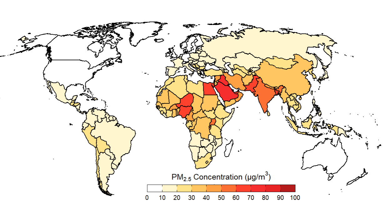
Population-weighted global PM2.5 exposure by country
Case Example: Brick Kiln Mapping in Northern India
Building India’s first state-level spatial database for industrial emission mapping.
The Challenge:
Brick kilns are one of northern India’s largest unregulated industrial emission sources. Despite their scale and contribution to particulate matter and black carbon, spatially verified data on kiln locations has historically been limited.
The Approach:
WEN conducted GPS-enabled field digitization and geospatial verification to build a state-level spatial database of kiln locations. These verified coordinates are designed for integration into emission inventories and atmospheric models.
What We Learned:
WEN conducted GPS-enabled field digitization and geospatial verification to build a state-level spatial database of kiln locations. These verified coordinates are designed for integration into emission inventories and atmospheric models.
Why It Matters:
WEN conducted GPS-enabled field digitization and geospatial verification to build a state-level spatial database of kiln locations. These verified coordinates are designed for integration into emission inventories and atmospheric models.
🌍 Emissions intelligence is the foundation upon which equitable and effective climate and air quality strategies are built.